
Storm Floris: Unseasonably strong 85mph winds to batter Scotland as Met Office issues weather warning

The strongest winds driven by Storm Floris are set to hit Scotland from Monday.
Storm Floris will batter Scotland with unseasonably strong winds reaching gusts of up to 85mph on Monday, the Met Office has forecast.
A yellow weather warning for wind is in place in Scotland, Northern Ireland, north Wales and the north of England from 6am on Monday to 6am on Tuesday.
The strongest winds are most likely across much of Scotland during the afternoon and night, with gusts of up to 85mph possible along exposed coasts and hills.
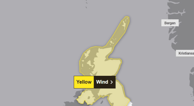

Heavy rain is also expected, with transport disruption expected.
Many inland parts of the warning area will see westerly gusts of 40-50mph.
The strongest winds will most likely affect Scotland on Monday afternoon and night, but “there remains some uncertainty in the depth and track of Floris”, the Met Office said.
The forecaster added: “Winds will first ease in the west during later Monday, but remaining very strong overnight until early Tuesday in the east.”
Met Office meteorologist Alex Burkill said: “It’s not that often that we get storms during the summer months, but it’s worth bearing in mind that at this time of year we could see some increased disruption because of the fact that the trees are full of leaf and there are lots of outdoor activities planned.
“You may be camping, you may be trying to head to a festival … as a result we could see some significant impacts because of not only the rain, but also the winds.”
The Met Office said some damage to buildings, such as tiles blown from roofs, could happen. There is also a risk of injuries and danger to life from flying debris.

Power cuts may occur, with the potential for other services, such as mobile phone coverage, to be affected.
Those travelling across Monday and into Tuesday have also been warned that some roads and bridges may close, and road, rail, air and ferry services may be affected, with longer journey times and cancellations possible.
With the storm due to hit during the peak summer season, the Met Office has issued extra guidance for people enjoying the outdoors.
It is urging people who may be heading to the coast to check tide times, and stay away from cliff edges and stormy seas. It also has tips for how to stay safe while camping during stormy weather.
The Met Office said people should put away outdoor furniture and tie down trampolines, while those towing trailers and caravans, as well as those with roof and tent boxes, must ensure their loads are properly secured.
Storm Floris is the sixth named storm of the 2024-25 naming season, which runs from early September to late August. January’s Storm Eowyn was the most recent.
Named storms are more frequent in late autumn and winter but are “not uncommon” for summer, the Met Office said.
Network Rail have extra teams on standby, including chainsaw-trained staff in the event of trees or debris being blown onto tracks. Speed restrictions on trains may also be introduced, the network operator said.
Ross Moran, route director at Network Rail Scotland, said: “We know Storm Floris is likely bring unseasonably strong winds and disruption and we’re working hard behind the scenes to make sure we’re ready. Our priority is keeping passengers and our staff safe.
“Our teams are already carrying out extra inspections and putting plans in place, including extra support. That work will continue throughout the storm, with staff on standby to respond quickly to any damage.”
Comments
Want to join the conversation? Please or to comment on this article.